Lost Cities
Images from a spy’s toolkit are helping a Harvard-led team uncover the landscapes and the cultures of the ancient world.

The Neo-Assyrian kings talked a big game.
They had plenty to brag about. In the seventh century BC, the Neo-Assyrian Empire was at the crest of its power. It had conquered lands from the Caucasus to Egypt, and forcibly relocated whole villages from Palestine to northern Mesopotamia. In Niniveh, the world’s largest city, the king Sennacherib, who ruled from 704 to 681 BC, led the development of an elaborate system of irrigation canals that fed the capital’s grandiose gardens.
Like his father Sargon II, Sennacherib informed posterity of his achievements by way of inscriptions on the palace walls. “I tore open mountain and valley with iron pick to dig a canal,” he announced, for example. “I made streets and avenues as light as day…”
But in his office on the top floor of the Peabody Museum at Harvard, Jason Ur, the John L. Loeb Associate Professor of the Social Sciences and a landscape archaeologist who specializes in the ancient Near East, greets the bravado with a note of caution.
“Royal inscriptions are ideologically suspect,” Ur says. “Kings lie; emperors lie. In the past we have been eager to take these inscriptions at face value. But they were highly propagandistic and designed to promote a particular royal ideology.”
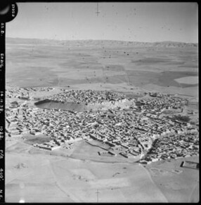
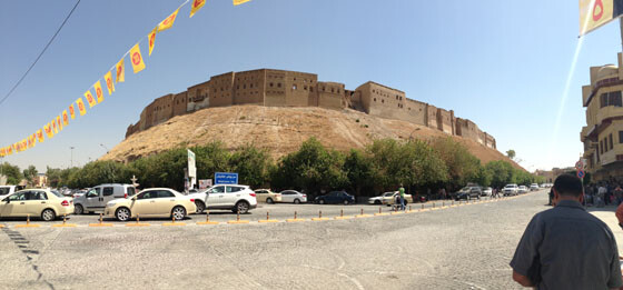
Ur unrolls a large photographic print and flattens it on the conference table. It is an aerial photograph, in black and white, of a landscape about fifty kilometers squared. Two rivers are apparent, along with a city, and many fields. Hills rise near the photograph’s edge. This is the Erbil Plain, in what was the heart of Assyria and is now Iraqi Kurdistan.
“Sennacherib made these unbelievable claims about canals and irrigation, moving water from all over the Empire and bringing it in the direction of Niniveh,” Ur says. “These are things that would require vast amounts of control and labor – by humans and donkeys. So my contribution here was to take a look at whether I could find the canal evidence.”
On the aerial photograph, the shades of gray reveal nuances and interruptions that emerge as one trains the eye. As Ur points out examples, it becomes clear that the rural Erbil plain, away from the ancient city, is replete with locations to investigate.
“You see that white blob? It’s almost certainly a mound. I can tell it’s shedding moisture because it’s reflecting white. I’m 99 percent sure it’s an archaeological site.” His fingers move across the map. “This here is a massive canal. It would have enabled irrigation of all this area between these two natural drainages. So the working hypothesis is that this is one of the big irrigation systems that the kings claimed.”
But the photograph is modern; to be precise, it’s a declassified American spy satellite photo taken in the late 1960s. And the intriguing hints it offers aren’t clearly delineated by historical epoch. Scanning the image, Ur points out the signs of settlements, canals, and the underground waterways known as karez, which appear as dotted lines that show the shaft locations. Some of these landscape modifications could date back to the Bronze Age, long before Sennacherib. Others could be as recent as medieval times.
“I can identify these features and make hypotheses about what they say about the society that produced them, but I need to get to the ground and pull apart these landscapes into periods of time,” Ur says. “There are limits to what you can do just from space.”
Since 2012, Ur has led the Erbil Plain Archaeological Survey (EPAS), an international project that seeks to inventory 1,200 sites in the region on the photo, a diamond-shaped area of some 3,200 square kilometers with Erbil – the capital of Iraqi Kurdistan – at its center. The team is visiting each site to assess its value, collect evidence, and attribute activity to the appropriate era, from the Neolithic to the present.
The team will produce maps of successive roads, waterways, and settlement patterns on this terrain. The painstaking work is already yielding an appreciation of the landscape’s modification over time, in response to political, demographic, and economic forces. Sennacherib’s canals, for example, turn out to be a much larger network than expected, and one that fed many rural zones, not just Niniveh, demonstrating a region-wide, large-scale agricultural infrastructure policy.
Funded by the National Science Foundation (NSF), National Geographic Society, and Dumbarton Oaks, the five-year EPAS initiative is building a database that will serve scholars as well as local antiquities officials in a region where rapid development threatens to disrupt or overrun many as-yet unexplored sites.
“The Erbil plain has a denser archaeological landscape than any other surveyed place in Greater Mesopotamia,” Ur says. “It’s a fantastically rich environment – and one that we knew nothing about a few years ago.”
Most of Iraq has been well surveyed, Ur says, but not this part. Successive Iraqi regimes marginalized the Kurdish community and discouraged research in the restive region. The Ba’athist regime that took over in 1968 emphasized southern Mesopotamian cultures of ancient Sumer and Babylon – not Assyria, in the north – in the country’s official history.
As Saddam Hussein’s rule hardened, things got worse, as repression culminated in the depopulation of the Kurdish countryside and in chemical weapons attacks on rebellious villages in 1988. Needless to say, foreign archaeologists were not welcome.
“There is a real gap in knowledge of the history of the Kurdish region,” Ur says. “And the local antiquities people, if they’re going to write their own history – which I think everybody should be able to do – they need to know where these places are.”
What makes the work possible now, crucially, is the calm that prevails in the region. Iraqi politics are fraught, and security in the south remains volatile, but the Kurdish region is autonomous and generally stable and safe. Westerners, and particularly Americans, are welcome. An oil boom has attracted investment. Direct flights to Erbil from Vienna, Istanbul, or Dubai allow visitors to bypass Baghdad altogether.
The other key to the work is the aerial photographs that allow Ur and his team to identify the locations to visit across a sprawling, mostly agrarian terrain. They come from a trove of 800,000 photographs from CORONA, America’s first spy satellite program in the 1960s. The photos, and a subsequent set from a spinoff program called KH-7, were declassified starting in 1995 and became available to researchers a few years later.
“It’s a great victory for government openness,” Ur says. “And I like that we can take the images to the people we spied on, and use them to work with our Iraqi colleagues.”
The age of the images is not a handicap. In fact, it helps that they show the landscape prior to disturbance by the last few decades of development. Combine them with contemporary tools like Google Earth and GPS locators to carry in the field, and archaeologists around the world are discovering new research vistas.
“A regional approach has grown, asking questions not of individual sites where you have to go and dig, but ones that demand a broader perspective: like the origins of cities and states, and how they work,” Ur says. For research on Mesopotamia, he says, landscape archaeology and its new tools have brought about “a bit of a renaissance.”
The timing was right for Ur. (His last name is Hungarian, and has nothing to do with Ur, the Sumerian city, although he laughingly allows that “it does make it look like I have taken a stage name.”) He began his PhD studies in Mesopotamian archaeology at the University of Chicago just before the CORONA images became available. His mentor, the landscape archaeologist Tony Wilkinson, who is now at Durham University in England, recognized the potential of the satellite photographs and urged his advisees to exploit them.
“Tony had bought the images – you couldn’t get them digitally then,” Ur says. “He projected them against a piece of paper taped to the wall and hand-traced the features. What his students have done is to run with this in a digital domain, in the same way that other social sciences are taking advantage of geospatial tools.”
Ur’s dissertation and later research took him to northeast Syria, where he joined, among other projects, a study of the Tell Brak site – one of the world’s first cities, dating to the fourth millennium BC. Mapping and collecting fragments from a broad landscape, he helped show that Tell Brak did not grow out from a core, but filled in as a number of associated but separate settlements expanded toward one another. The finding challenged the conventional view that urban expansion resulted from centralized decision-making.
It also confirmed Ur’s instinct that the stories rulers tell about how they built cities and states need taking with a grain of salt. Landscape archaeology, as he sees it, can help correct a bias, which he describes with the vocabulary of the Occupy movement.
“We are no longer limited to what the early excavators chose to focus on, which was disproportionately the 1 percent,” he says. “We know the nooks and crannies of the great Assyrian palaces in a way that would probably horrify the kings themselves. But we know nothing about the rest of the population of Niniveh, let alone the villages that surrounded it or the countryside between the spaces.
“The new approaches allow us to fill in both geographically and socio-economically: you get a broader picture of society in these early states and civilizations.”
On the ground, the work is arduous. For several weeks each summer, the team – which includes scholars and graduate students from the US, Canada, Netherlands, France, and more, with specialties in different periods of the region’s history – sets out to scour sites that the remote-sensing analysis has identified.
“We stumble out of bed at 4 a.m. and prepare many liters of water,” says Jon Clindaniel, a Harvard graduate student who has taken part each year and whose dissertation Ur will advise. “We drive out in the dark so we can get work in before it gets too hot. We’re looking for pottery, for metal; this past year we found a tablet on the surface.”
The work involves explaining to villagers why a dozen strangers want to criss-cross their fields, hunched over; placating aggressive dogs; and accepting many offers of tea. Some areas that looked uninhabited on the photos turn out now to be built-up villages.
“There, we shift to being more like anthropologists,” Ur says. “Very often, the people living there don’t understand the significance of the mound at the heart of their village. We try our best to explain, so people know that they live in a historically important place.”
The survey is occurring in a changing landscape. A major challenge, Ur says, is the fast growth of Erbil, where stability and the oil boom are attracting workers and overseas Kurds investing back home. New neighborhoods are springing up with little regard for preservation of sites that people may not know exist in the first place. Construction also drives demand for river gravel for concrete, damaging sites along the region’s waterways.
“We’re homing in on the most threatened areas,” Ur says. “And we’re incorporating a local training element, because there’s no way one foreign team can stay ahead of a million-person city that’s growing so fast.”
The pressure compounds the complexity of a project that must also deal with the imperative of building local research capacity and with managing relationships with Kurdish antiquities officials and the typically cooler central authorities in Baghdad. The Syrian civil war, meanwhile, has led some of Ur’s Syrian colleagues to take refuge in Erbil, and he is trying to find ways to involve them in the project.
Clindaniel says Ur navigates this milieu smoothly. “He’s a great politician,” Clindaniel says. “Half of archaeology is waiting around in offices. He always carries around his map canisters and will unfurl them in various offices. He has great presentation skills, and he’s good at visualizations.”
One goal that Ur visualizes is a revival of research in Iraqi Kurdistan that his project – the first led by an American – can help seed. “I’ve been active in encouraging colleagues, especially those whose Syrian projects are on hiatus, to join me,” he says. “After all, I know where the interesting sites are. I can give them precise coordinates.
“The intellectual justification is ultimately what drives me,” he adds. “But shortly behind that is this element of doing the right thing for a part of the world that hasn’t been well served in the past century. There are so many good reasons to be in this place.”
Photo by Jason Ur.